
Edakkal Caves
Edakkal Caves, located south of Sulthan Bathery is the flagship attraction of Wayanad tourism. A must do in Wayanad. though not for the weak hearted, thanks to the grueling climb involved!
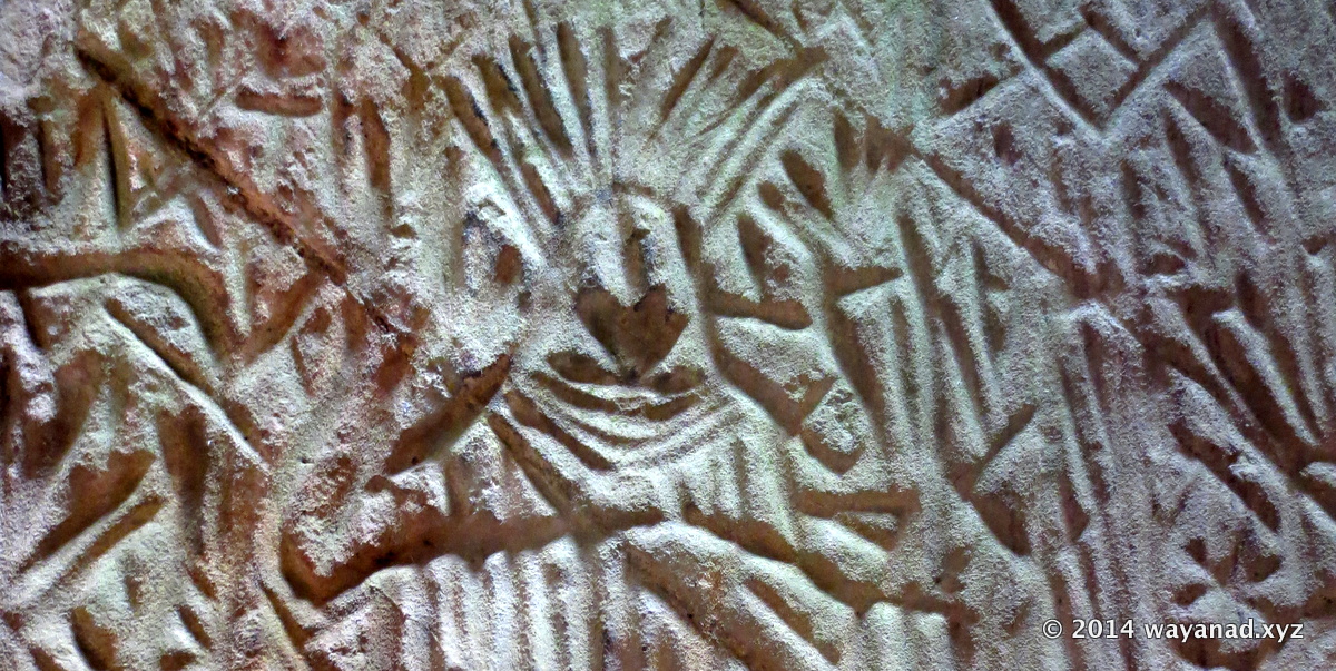
Petroglyphs of the Tribal King. Edakkal Caves , Wayanad
Petroglyphs of the Tribal King. Edakkal Caves , Wayanad
A
dd Edakkal Caves in your Wayanad itinerary.From a historic point,Edakkal Caves represent one of the oldest human settlements in the world. The the origin is unknown, historians dates it back to 1000 BC, and some even to 6000 BC.
From an artistic standpoint, the Petroglyphs (rock carvings) are massive, spectacular and animate. They express the attitudes and lifestyle of the people who lived here.These carvings are easily in the list of oldest surviving artworks in the world.
From a tourism point, Edakkal Caves offers a pleasant mix of Nature,Adventure,Trekking and Heritage. Edakkal Caves is a sought after destination in Wayanad. You can make a trip to Wayanad, solely to visit Edakkal Caves and feel happy about it!
How to tour Edakkal Caves: Let's consider the fitness factor first before you add Edakkal Caves to tour Wayanad itinerary. Visiting Edakkal Caves means you needs to be reasonably physically fit for a mini trek. If you are traveling with little kids, be prepared to carry them while trek up and down.
Trek is split into two sections. From the parking area around the village square to the ticket counter, midway is a paved uphill road. No private vehicles are allowed. Though uphill, this is a relatively easier part of the trek. You may also opt for the shared jeep service operated by the district tourism promotion council.
The second lap of the trek start after the ticket counter.
The harder part of the trek to the caves start from the base point where the entry ticket counter is located. The path up to the cave site is a combination of paved trails, steps made of stone, scrambling through boulders and climbing metal ladders.
At places the climb is pretty steep or negotiating through narrow path between massive boulders. There are quite a few youtube videos out there taken by people while trekking to the Edakkal Caves. These would give you a good idea of the type of trek.
From the ticket counter to the cave at the hilltop, you should reach in an hour's time. During the rush season (weekends, holidays etc) visitors are let into the cave as batches. You may end up in waiting in the queue longer than to trek uphill.
First things first. Edakkal Town at the foothills is where you can park your vehicle. There is a large ticketed parking lot.
Entry point for the trek is a short walk (1km uphill) from the parking area. You can also opt for a jeep service from the parking area till the ticket area. Buy tickets at the base of the trek trail. Buy camera tickets if you are carrying one.
Edakkal Caves is a no plastics zone. If you are carrying plastic water bottle, a refundable deposit to be paid. On return, show the plastic bottle with the deposite label to get the refund. Taking those snacks in those plastic bags up to the caves is a big no. Baggage is checked. Rules are enforced strictly.
Travel light. Take just what is required. Most Likely you should be happy with a bottle of water,camera,hat,wallet and any other personal essentials required for a 2-3 hours trek.
Wear a pair of shoes. Better if you have a pair of hiking footwear. If not a, good pair of canvas shoe would do the job. Avoid those sandals and flipflops.
Carry a hat or cap. (They sell it near the car parking area). Some of the trek is through open area.
After the ticket counter, you'll first scale some 300 or so steps along the thickly wooded hillside. The most difficult to climb trails are installed with metallic ladders with railings. You'll see many small 'caves' on the way. The final one is a massive enclosure where the engravings are located.
How Long will it take to visit Edakkal Caves: Well, ideally you need to reserve a full day in the Wayanad itinerary to explore Edakkal Caves.
On a non-busy day, it can take anything from 2-3 hours to trek up and down from the Edakkal town square. On a busy holiday season, the queue can slowdown the tour further. Add another 1 hour or so to explore and take a short break at the caves.
Excursion to Edakkal drains your energy, unless you are a trekking enthusiast. Now, even if you have time you may not be very energetic to explore another site the same day. Those traveling with family/groups consider everyone's energy levels before making the day's itinerary.
Nevertheless you can pack more destinations in the itinerary, if you prepare well and start early. Keep Edakkal and the main item of the itinerary. Be at Edakkal during the opening hour. You can also pick and add a couple of less strenuous sites like the Heritage Museum in Ambalavayal , a visit to the local RARS nursery, Phantom Rock , Jain Temple in Sulthan Bathery before call it a day.
Attractions in Edakkal Caves: The star attraction are the Petroglyphs (rock carvings) in the main cave. Out of this the image of the tribal king is the masterpiece. You can also spot the queen, a child, a deer and an elephant engraved on the cave wall.
Otherwise the inner wall surface of the cave is richly carved with various shapes, motifs and symbols. One of the interesting thing to do inside the caves is to look for shapes and symbols you can identify (human figures, plants, animals, tools...).
The Edakkal Cave itself is a peculiar geologic formation. This is not a cave in literal sense. This massive cave like shelter is formed as cleft between rock formation. Once inside the main cave, look upward. You can see massive wedge shaped boulder 'hanging' from the 'roof' of the cave. This boulder appears precariously trapped between the the massive sheets of rocks that forms the cave. It's a bit scary but thrilling to stand under this hanging boulder. In fact the name Edakkal in local dialect means `a stone in between’, referring to this suspended boulder.
Very close to the main cave is a chimney formation. There is a narrow parallel vertical cleft between two skyscraping boulders. The cleft is just a couple of feet apart, and astonishingly parallel. You can look up and down, sanding close to this clift. There is a grilled protection to prevent people going to the edges of the cleft, as it is not safe. Nevertheless you can see the chimney formation through the protective grills.
The panoramic view from outside the main cave is brilliant.
There are quite a few legends to are associated with the caves. Ambukithimala, the mountain where Edakkal Caves are located is associated with a folklore. According to this , Lord Rama killed Demon Ravana's sister Surpanakha in this cave.
So how did the caves origin. Was it manmade or natural? The caves are located in a mountain called Ambukuthi Mala. In local dialect Ambukuthi Mala literally translates 'the mountain where the arrow fell'. According a local legend, the caves were in fact formed by the arrows shot by Lava and Kusha, the two sons of Rama and Sita.
From the geological standpoint the caves could have formed due to an earthquake. In traditional sense these are not caves, like a hole in the mountain. The cave like space is formed by a fissure in a massive rock. In that event, a cyclopean boulder got trapped between the fissure, forming the roof.
The major cave measures approximately 96 feet (29 meters) long, 22 feet (6.7 meters) wide and 30 feet (9.1 meters) heigh. So inside you'll not feel like a cave, rather as a massive art gallery, literally!
Attractions Near Edakkal Caves:
Apart from the trek up the Edakkal Caves, there are quite a few attractions around the Ambalavayal area. If you are traveling to/from the national highway (NH 212), Phantom Rock is just a short detour from the Kolagappara road.
The Wayanad Heritage Museum (also called the Ambalavayal Heritage Museum) is one among the top tribal heritage museums in the country. The museum is located in the Ambalavayal town centre, about 5km from the Edakkal town.
Regional Agricultural Research Station (RARS) is research institution part of the Kerala Agricultural University. If you are a gardening enthusiast visit the RARS nursery. You can buy high quality seeds and planting materials from the sales counter attached to the nursery. RARS is just out of the Ambalavayal town square.
How to Reach Edakkal Caves :
Edakkal Town , about 1km from the base of the mountain is the closest road connection.
Edakkal is about 12km south of Sulthan Bathery town, 28 km east of Kalpetta and 45km south of Mananthavady. Ambalavayal, the local town is about 6 km west of Edakkal.
Local bus services are available. Or hire a jeep.
If you are traveling by car/bike drive all the way upto the Edakkal Town, where the parking space is located.
Further you may trek up to the ticket counter (about 1km) or use the shared jeep service (Rs50) by the tourism promotion council. Beyond the ticket counter, it's an exhausting trek.
From Sulthan Bathery take the Kalpetta road (NH 212). About 6km from Sulthan Bathery you'll reach a junction called Kolagappara. Leave the highway and turn left. This will take you towards Ambalavayal.
About 4km after Kolagappara junction, the otherwise curvy road will make a few hairpin like bends. You'll arrive a Y-fork junction called Ayiramkolli. The straight road will lead to Ambalavayal town. Take the left hairpin bend at this junction for Edakkal. It's about 4km from Ayiramkolli junction.
On return from Edakkal, if you are heading towards Meppadi, Vaduvanchal, Nadugani,Ooty etc, head straight at the Ayiramkolli junction.
Edakkal Caves Timings:
Caves are open from 9am till 4pm. Edakkal Caves is open for visitors throughout the year.
Closed on all Mondays . Also note other holidays in the year when the caves are closed : Republic Day (January 26), May Day (May 1), Independence Day (August 15), Gandhi Jayanti (October 2) and Thiruvonam Day (a day in late August or early September).
Edakkal Caves Entry Fees: Buy ticket directly from the ticket counter midway the route up the hilltop. Deposit for taking plastic plastic bottles is located next to the entry ticket counter.
Adult : Rs10
Child : Rs5
Still Camera : Rs25
Video Camera : Rs100
Cautions: Do not venture out of the designated trekking route. Trekking into the forest other than the marked trail to the caves is prohibited by law.
Carrying eatables not encouraged. The area has plenty of monkeys. Take care of your bags as monkeys looking for edibles could snatch handbag.
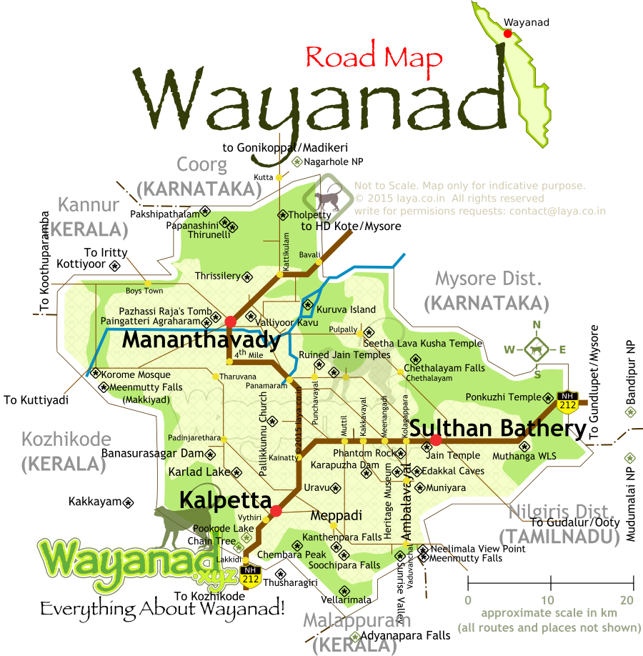
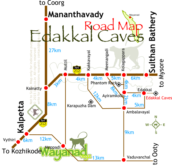
Wayanad District road map for the main tourist circuits.
Major highways and routes to reach the popular tourist attractions in Wayanad is listed in the map.
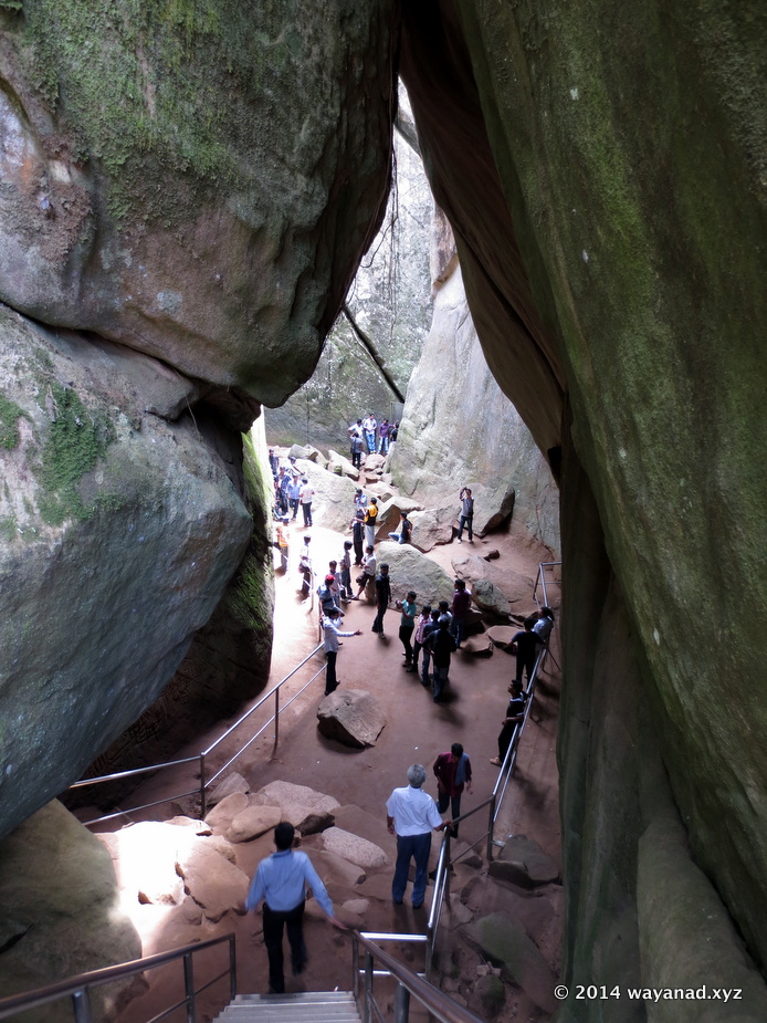
The final part of the trek decents into the Edakkal Caves
The most difficult to climb trails are installed with metallic ladders with railings. You'll see many small 'caves' on the way. The final one is a massive enclosure where the engravings are located.
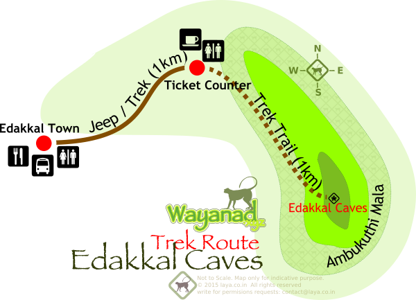
There are two stretches of trek . First from Edakkal town to the ticket counter location and the second from the ticket locatio to the Ambukuthimala hilltop.
Trek is split into two sections. From the parking area around the village square to the ticket counter, midway is a paved uphill road. No private vehicles are allowed. Though uphill, this is a relatively easier part of the trek. You may also opt for the shared jeep service operated by the district tourism promotion council.
The second lap of the trek start after the ticket counter.
The harder part of the trek to the caves start from the base point where the entry ticket counter is located. The path up to the cave site is a combination of paved trails, steps made of stone, scrambling through boulders and climbing metal ladders.

Major attractions in Wayanad, grouped region wise. Organise your itinerary and travel route suitably.
Wayanad Tourism attractions map with hotspots. The regions are highlighted in the map based on the road routes to plan your Wayanad itinerary.
1. List of the attractions in the Kalpetta, Meppadi,Sulthan Bathery and Ambalavayal area of Wayanad.
2. List of attractions located at the west of Wayanad , between Kalpetta and Mananthavadi.
3. List of north Wayanad attractions beyond Mananthavady and around Kattikulam area.
4. List of east Wayanad attractions between Kuruva Island and Sulthan Bathery
Edakkal Caves Route Map
Edakkal Caves Route Map with approximate distances.
Wayanad District road map for the main tourist circuits.
Major highways and routes to reach the popular tourist attractions in Wayanad is listed in the map.
Wayanad District road map for the main tourist circuits.
Wayanad Tourism Road Map
Major highways and routes to reach the popular tourist attractions in Wayanad is listed in the map.
The final part of the trek decents into the Edakkal Caves
Edakkal Caves in Wayanad
The most difficult to climb trails are installed with metallic ladders with railings. You'll see many small 'caves' on the way. The final one is a massive enclosure where the engravings are located.
There are two stretches of trek . First from Edakkal town to the ticket counter location and the second from the ticket locatio to the Ambukuthimala hilltop.
Edakkal Caves Trek Route Map
Trek is split into two sections. From the parking area around the village square to the ticket counter, midway is a paved uphill road. No private vehicles are allowed. Though uphill, this is a relatively easier part of the trek. You may also opt for the shared jeep service operated by the district tourism promotion council. The second lap of the trek start after the ticket counter. The harder part of the trek to the caves start from the base point where the entry ticket counter is located. The path up to the cave site is a combination of paved trails, steps made of stone, scrambling through boulders and climbing metal ladders.
Major attractions in Wayanad, grouped region wise. Organise your itinerary and travel route suitably.
Wayanad Tourism hotspot map
Wayanad Tourism attractions map with hotspots. The regions are highlighted in the map based on the road routes to plan your Wayanad itinerary. 1. List of the attractions in the Kalpetta, Meppadi,Sulthan Bathery and Ambalavayal area of Wayanad. 2. List of attractions located at the west of Wayanad , between Kalpetta and Mananthavadi. 3. List of north Wayanad attractions beyond Mananthavady and around Kattikulam area. 4. List of east Wayanad attractions between Kuruva Island and Sulthan Bathery
Edakkal Caves Route Map
Wayanad District road map for the main tourist circuits.
Wayanad Tourism Road Map
Major highways and routes to reach the popular tourist attractions in Wayanad is listed in the map.