
Bangalore to Mananthavady via Nagarhole
This is arguably the less frequented and more exciting route from to Wayanad from Bangalore , thanks to the drive through the Nagarhole forest!
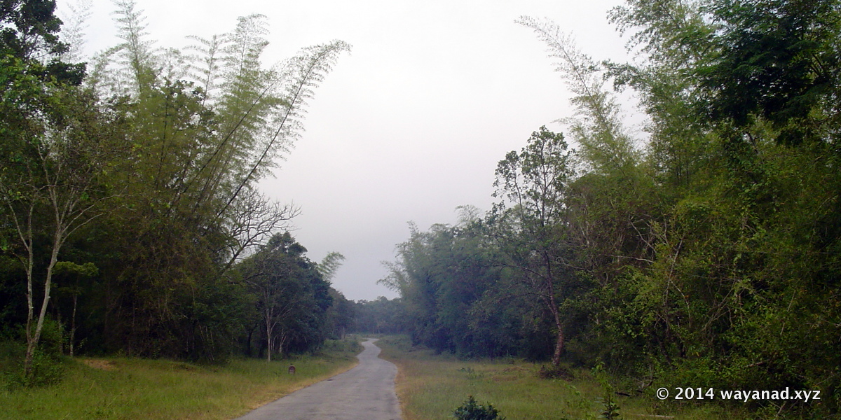
Road through Nagarhole Forest
Road through Nagarhole Forest
D
istances from Bangalore to Mananthavady via Nagarhole and route is like this : Bangalore – 150km –> Mysore — 45km –> Hunsur — 20km –> Nagarhole entry gate — 30km –> Nagarhole exit gate — 4km –> Kutta — 18km–> Kattikulam — 10km –> MananthavadyCheck the other two popular routes between Bangalore and Wayanad.
You want may want to bypass Mysore city... Take the bypass road that appears on your right after Srirangapatna town. This is the road you need to take to reach KRS (Brindavan Gardens) and Ranganathittu Bird Sanctuary located near Mysore.
This bypass road joins the Hunsur road (SH88) at Elivala, way after Mysore city. This bypass route is about 16km between Srirangapatna and Elivala.
It is a decent road, but no way comparable to the highway you have been before the deviation. Of course you can go right through Mysore city or even by the Outer Ring Road (that is around the city) , both will eventually bring you on the SH88 to continue by Route A towards Hunsur.
At Elivala (Yelwal) you are now back on the highway (SH88) again. 30km on SH88 from here, you’ll reach Hunsur town. The road from Mysore city to Hunsur (State Highway 88) is as marvelous, even better than the Bangalore-Mysore highway (SH 17). You can drive faster as SH 88 is not having the traffic as compared to SH 17. It’s 4 lanes most of the way.
As you approach Hunsur, the highway makes a Y fork. Take the left (rather straight fork, as the highway bends rightward). At the junction, there is a huge board indicating the direction to the wildlife sanctuary. You’ll reach the crowded Hunsur bus station area.
This crowd announces the end of super-fast driving pleasure. Look out for a narrow road on your left right after the bus station. You may even spot a tiny signboard showing direction to Nagarhole and Iruppu Falls. If in doubt, ask for direction to Nagarhole (Do not ask for Wayanad , as you may not get a quick or right answer from a layman by the road side).
Now you are on the road from Hunsur to Kutta, via Nagarhole forest (a.k.a Rajiv Gandhi National Park ). It may take a few more minutes to shift the gears in your mind as this road is narrow (just as wide as a bus) and pothole ridden. On top of it, you have to ask for help at a few confusing village squares so that you can ensure you are in the right direction to Nagarhole. It’s worth the trouble. Plus, you may learn a bit of vernacular Kannada!
After about 15 kilometers from Hunsur, you regain the rhythm of driving. Surprisingly, the road starts getting better though it will be narrower. You will start enjoying the remoteness rather than the whiz, as you were till Hunsur.
Now comes the Karnataka Forest departments check post and that formidable green painted gate across the road. The gate won’t lift open automatically as you tend to wish. You have to stop the car and go to the tiny shed next to the gate to register your entry. It’s a simple procedure hardly takes 3 minutes if there is no queue. Details like vehicle’s registration number, your name, destination, number of passengers, etc; has to be entered and finally you need to sign in the register. It is not unusual if a small tip is expected!
The gate will open and you are into the Nagarhole reserve forest. The road is in reasonable condition with humps built across the road every few kilometers. One is expected to drive slow as wild animals may cross the road at any point across your road. Somewhere in the middle, you will cross a few tribal settlements, the Murkal Elephant camp and the Nagarhole safari point before you exit the forest.
Remember a few things: Traffic is allowed to pass through Nagarhole forest only from 6 am to 6 pm. You've to pay no fees to cross the forest. Also, you should not park your vehicle anywhere in the forest. Do not stray into the forest, as it is against to rule and can be dangerous. Just drive carefully along the designated road and cross the forest. You will be just fine.
What if you spot wild animals on the road? Bisons and elephants are known to charge, if provoked.Keep distance and silence, they drift away.
A few turns after you exit the forest, you reach the small border town called Kutta. Between Hunsur and Mananthavady, Kutta is the only place where you can get some facilities (such as water, food and toilets). Look for a steep left turn as you enter Kutta. This is the road that goes to Wayanad again through a forest, though it is not as isolated as Nagarhole forest range. If you want to take a break anyway, head into Kutta town without taking the left fork mentioned above. The town square is about half kilometer from the fork.
You enter Kerala soon after Kutta. A signboard in Malayalam announces that you are entering Kerala state.
The roads in Kerala are in better conditions. The road, in the Kerala side of the forest, is wider than the one through Nagarhole. So is the traffic.
You are now very well into Wayanad. However terribly you've fared in those geography classes, you can easily tell now that you are in the lap of the evergreen misty Western Ghats.
In a few minutes drive, you will cross the entrance of Tholpetty Wildlife Sanctuary. You can spot a large number of tourist vehicles parked on either side of the road and the traffic on the main road literally wriggles through this crowd. This sanctuary is the first attraction in Wayanad as you enter the district by this route. Many kilometers ahead, still on the forest road towards Mananthavady, you will reach a junction. Take the right fork (called the Thettu road) to go towards Thirunelli Temple, Papanashini or to Pakshipathalam (trek to forest for bird watching). It’s about 15 kilometers from the junction.
Otherwise, you can head straight to Mananthavady. Shortly the forest thins out and the environs appear to be more populated, you'll arrive at a small town called Kartikulam. Just before that you'll spot the left deviation towards Kuruva Island (6km through the forest, again!); continue straight on the highway for Mananthavady town (10 kilometers).
Note : Traffic through the Nagarhole forest is not allowed between 6pm and 6am. Also two wheelers are not permitted in the forest on this route. From Bangalore up to Hunsur, the road is in great shape with many travelers facility available en route. Beyond Hunsur, till Kerala border (about 60km) the road condition is moderate to bad.
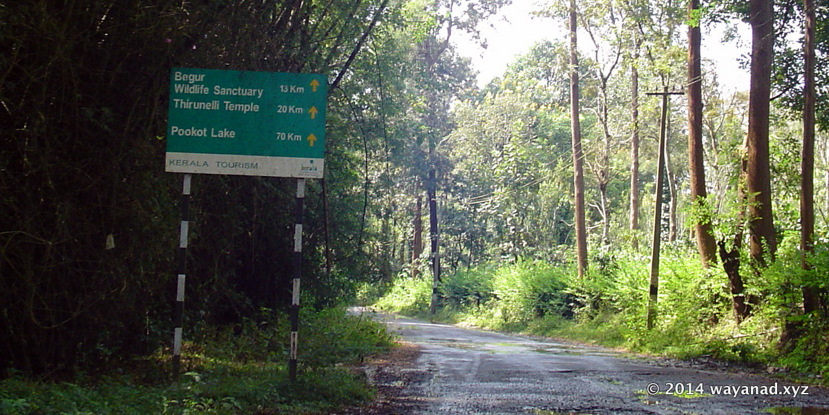
Signpost at Kerala border near Kutta.
Distances from Kerala border near Kutta. Begur WLS: 13km
Thirunelli Temple: 20km
Pookote Lake : 70km
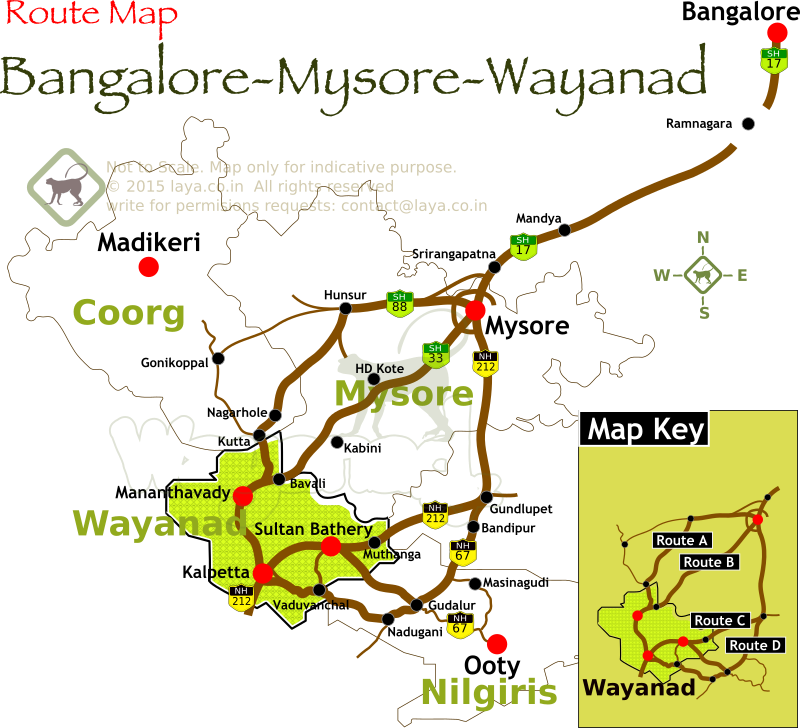
Bangalore Mysore Wayanad Route Map
Route A : Bangalore to Wayanad via Mysore, Hunsur, Nagarhole NP, Kutta and Mananthavadi
Route B : Bangalore to Wayanad via Mysore, HD Kote, Kabini, Nagarhole and Mananthavadi.
Route C : Bangalore to Wayanad via Mysore, Gundlupet, Sulthan Bathery and Kalpetta.
Route D : Bangalore to Wayanad via Mysore, Gundlupet, Bandipur , Gudalur and Kalpetta.
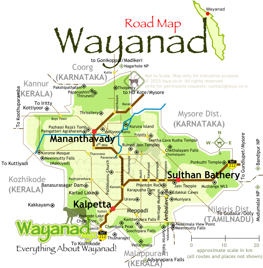
Wayanad District road map for the main tourist circuits.
Major highways and routes to reach the popular tourist attractions in Wayanad is listed in the map.
Signpost at Kerala border near Kutta.
Road Signpost at Wayanad
Distances from Kerala border near Kutta. Begur WLS: 13km Thirunelli Temple: 20km Pookote Lake : 70km
Bangalore Mysore Wayanad Route Map
Wayanad District road map for the main tourist circuits.
Wayanad Tourism Road Map
Major highways and routes to reach the popular tourist attractions in Wayanad is listed in the map.